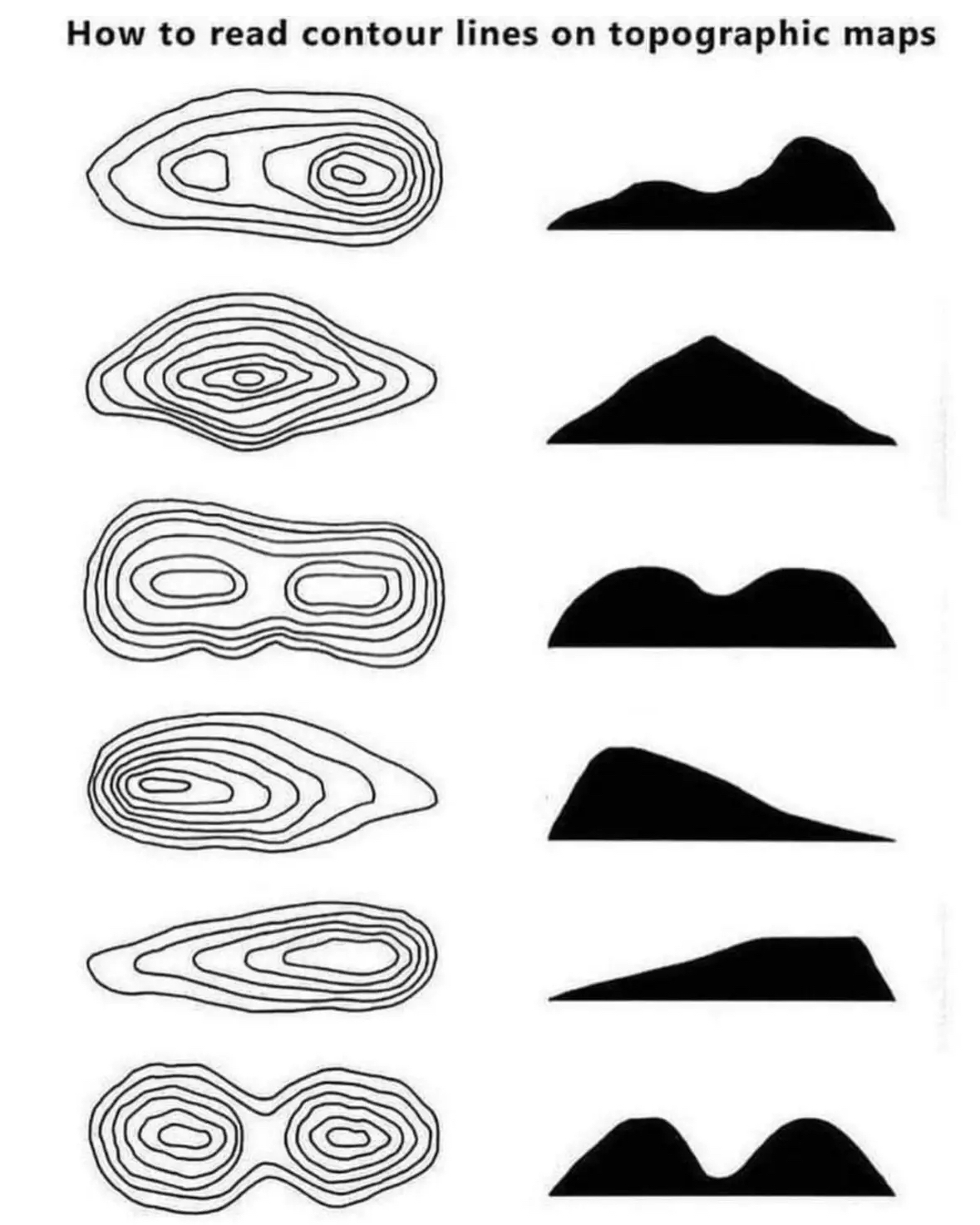
111000@reddthat.com to Cool Guides@lemmy.caEnglish · 2 年前How to read topographic mapsreddthat.comimagemessage-square51linkfedilinkarrow-up1422arrow-down133
arrow-up1389arrow-down1imageHow to read topographic mapsreddthat.com111000@reddthat.com to Cool Guides@lemmy.caEnglish · 2 年前message-square51linkfedilink
minus-squareBCsven@lemmy.calinkfedilinkEnglisharrow-up20·2 年前Do you have an example, I either never have seen this or never had a depression on a map
minus-squaremisterdoctor@lemmy.worldlinkfedilinkEnglisharrow-up32·2 年前You want an example of local depression just swing by my place anytime
minus-squareIlliterate Domine@infosec.publinkfedilinkEnglisharrow-up19·2 年前Here’s a slide describing how depressions are represented, and here is a topographical map of a sinkhole showing the hashes. That said, I had to look pretty hard for a map with those marks. Numbers are much more common.
minus-squareBCsven@lemmy.calinkfedilinkEnglisharrow-up6·2 年前Ah, awesome. i appreciate you taking the time to put this together. I dont recall these on maps, but as you said numbers are common. And i typically use the topomap with shading, so shading helps with understanding the terrain
minus-squareJessica@discuss.tchncs.delinkfedilinkEnglisharrow-up3·2 年前Page 2 under contours: https://pubs.usgs.gov/gip/TopographicMapSymbols/topomapsymbols.pdf
minus-squaresixCats@lemmy.dbzer0.comlinkfedilinkEnglisharrow-up2·2 年前That’s interesting, ordinance survey (in the UK) don’t do that, so it isn’t a universal standard In the UK, you have to notice that the heights are reducing

deleted by creator
Do you have an example, I either never have seen this or never had a depression on a map
You want an example of local depression just swing by my place anytime
heyoooo!
Here’s a slide describing how depressions are represented, and here is a topographical map of a sinkhole showing the hashes.
That said, I had to look pretty hard for a map with those marks. Numbers are much more common.
Ah, awesome. i appreciate you taking the time to put this together. I dont recall these on maps, but as you said numbers are common. And i typically use the topomap with shading, so shading helps with understanding the terrain
Page 2 under contours: https://pubs.usgs.gov/gip/TopographicMapSymbols/topomapsymbols.pdf
Awesome, thankyou
deleted by creator
That’s interesting, ordinance survey (in the UK) don’t do that, so it isn’t a universal standard
In the UK, you have to notice that the heights are reducing